Today I'll talk about the area around Bahia Honda. As you cross the Seven Mile Bridge, you will leave the Middle Keys area and enter the Lower Keys. The Lower Keys are not just lower down the island chain, they're also lower to the water, farther apart, and the whole area is much more natural, less populated, and a whole lot waterier. In fact, from Homestead to here you will have crossed 16 bridges in 86 miles - but you will cross 26 more in just the next 36 miles to Key West.
The south end of the Seven Mile Bridge will land you on Little Duck Key. On the bay side is a parking lot where you can park and walk out onto the old Seven Mile Bridge. The first half mile or so is accessible to foot and bicycle traffic and you can usually find fishermen on there. There is a gap preventing you from going farther than a half mile, and the bridge north of that gap is in serious disrepair.
Just past, on the ocean side, is Little Duck Beach. This is a small, free, public beach with changing rooms and picnic tables.
There is little else to see on Little Duck Key. The island is uninhabited. The original overseas highway bypassed this area on the ferry from Lower Metecumbe to No Name Key, and then later from Knight's Key to No Name Key. The railroad was just a few feet north (bay side) of where the highway is today.
Leaving Little Duck Key, you'll cross bridge #17 to Missouri Key. Missouri Key was named by railroad workers homesick for their home state. Missouri Key is also completely uninhabited, and like Little Duck Key, the railroad ran just north of where the road is today.
Bridge #18 will take you past Mile Marker 39 and across to Ohio Key. Ohio Key, like Missouri, was also named by homesick railroad workers. The old bridges parallel the new bridges here and can be walked on, biked on, and fished from. Nearly all of Ohio Key is covered by a 400+ site RV campground. The complex includes a swimming pool, a marina, tennis courts, many pavilions, and a small beach. Ohio Key is sometimes called Sunshine Key, which is also the name of the campground here.
 |
| The south end of Bahia Honda Key |
 |
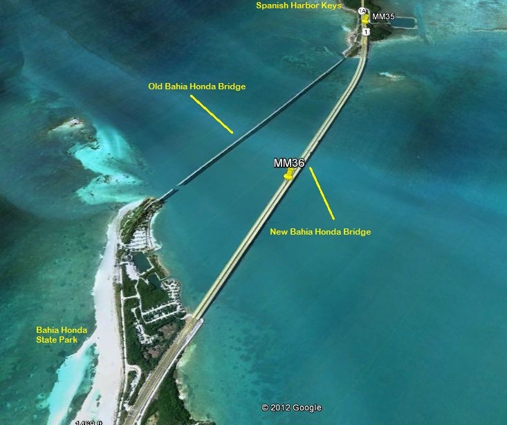
| The old Bahia Honda bridge |
To solve this unique challenge, the roadbed was instead built up on top of the trusses instead, leading to one of the most unique bridges in the Keys. This bridge was in regular use for over 60 years, as a train bridge from 1912 to 1935, then as a highway bridge from 1938 until the construction of the new bridge in the late 1970's. Today, the old Bahia Honda bridge is one of the most photographed spots in the Keys.
Crossing over bridge #20 will land you on Spanish Harbor Key. Spanish Harbor Key used to be three separate islands but were joined by fill during the railroad construction. The westernmost key is still sometimes called by it's original name, West Summerland Key - despite being 10 miles EAST of Summerland Key. There are several homes here on this island, but it's most notable feature are the construction warehouses that still remain standing to this day from the railroad construction. Some of the car chase scenes at the end of True Lies were filmed here too.
Leaving the Spanish Harbor Keys, SLOW DOWN as you cross bridge #21 to Big Pine Key! More about this in my next article, but slow down to 35 here. There's a good reason!